 |
 |
 |
FLOOD SURVEY
For
Land at Mill Lane & A1301 Junction,
Sawston
South Cambridgeshire
7 April 2012
Table of Contents
If this report has been released electronically, the appendices referred to herein can be found in the
annexed zip folder/s as .pdf or .dwg files. If this report has been released in hard copy the appendices
will be bound into the back of this report. Plans may be annexed separately as A1 or A0 copies where
a bound-in A3 copy is not appropriate.
1.0 Scope ........................................................................................................................................ 3
2.0 Executive Summary ................................................................................................................. 3
3.0 Introduction ............................................................................................................................... 4
4.0 Purpose of the Report ............................................................................................................. 4
5.0 Report Information Sources .................................................................................................... 4
7.0 Overview of British Legislation ............................................................................................... 5
7.1 National Planning Policy ..................................................................................................... 5
7.2 Local Policy ........................................................................................................................... 5
8.0 Site Status and Environmental Setting ................................................................................. 5
8.1 Site Location and Status ..................................................................................................... 5
8.2 Current Site Description ...................................................................................................... 6
8.3 Existing Flood Risk ............................................................................................................... 6
9.0 Assessment of Proposed Development .............................................................................. 10
9.1 Proposed Development ..................................................................................................... 10
9.2 Flood Risk Vulnerability ..................................................................................................... 11
9.3 Surface Water Runoff – Flood Risk from the Development ......................................... 11
9.4 Climate Change .................................................................................................................. 14
9.5 Flood Evacuation Plan ....................................................................................................... 14
10.0 Conclusion ............................................................................................................................... 14
10.1 Recommendations for Further Work ............................................................................... 15
11.0 Appendices .............................................................................................................................. 15
1.0 Scope
This report contains the details of a Flood Risk Assessment carried out by Arbtech
Consulting Limited (“Arbtech”) for the proposed development of Land at Mill Lane & A1301
Junction, Sawston, South Cambridgeshire.
This report has been prepared for Conrad Bay Ltd and must not be relied upon by any other
party without the explicit written permission of Arbtech Consulting Limited.
All parties to this report do not intend any of the terms of the Contracts (Right of Third
Parties Act 1999) to apply to this report.
Please note this report does not purport to provide definitive legal advice.
The Executive Summary contains an overview of key findings and conclusions. However, no
reliance should be placed on the Executive Summary until the whole of the report has been
read.
Other sections of the report may contain information which puts into context the findings
noted within the Executive Summary.
All rights reserved. No part of this report may be copied, edited, transmitted,
reproduced, hired, lent, sold or disclosed without the prior written consent of Arbtech
Consulting Ltd. Any action taken or omitted to be taken in reliance upon the content
of this report is not permitted and may be unlawful. Copyright © Arbtech Consulting
Ltd 2011.
2.0 Executive Summary
Arbtech conducted a Flood Risk Assessment for the site at Mill Lane & A1301 Junction,
Sawston, South Cambridgeshire. The site is approximately 0.3ha in size.
This FRA has been carried out in accordance with the 27th March 2012 National Planning
Policy Framework (NPPF) which replaced “PPS25: Development and Flood Risk”. It is to be
used to assist the Local Planning Authority (LPA) and Environment Agency (EA) when
considering the flooding issues of the proposed development as part of a planning
application.
The proposed development is to construct 3 commerical units, with associated car parking
and landscaping including SUDS in the form of ponds to ensure there is no change in the
hydraulic impact of the site.
According to the Environment Agency website map, the site is located within EA Flood Zone
2 (medium probability of flooding). The South Cambridgeshire Strategic Flood Risk
Assessment (SFRA) based on detailed modelling indicates the site is in Flood Zone 1 (low
probability of flooding). The site is therefore located in an area which is considered to have a
low risk of flooding.
The South Cambridgeshire SFRA indicates there was a flood recorded in the area which
included the site in 1968.
The site is protected from flooding by the embankment of the railway to the west and by the
A1301 to the east. The site itself has also been raised relative to the boundaries.
The drainage ditch to the south is culverted on either side of the site the site is protected
from surcharging due to the surrounding topography (A1301 and the railway). The proposed
buildings will not be located adjacent to the ditch.
Based on the SFRA mapping, there is safe access to the north of the site which is higher
ground and there is a large area within Flood Zone 1 as a safe refuge.15
The proposed development will incorporate an appropriate drainage strategy such that it is
considered there will be no unacceptable impacts on the adjacent infrastructure i.e. the
railway and A1301.
The most sustainable form of SUDS, in the form of attenuation pond(s) is to be incorporated
as part of the scheme. The pond(s) are to be sized using the 1 in 100 Year + Climate
Change storm event, to ensure there is no impact on the receiving ditch. The pond will also
act as a reed bed foul water treatment pond and will also operate as a benefit to biodiversity.
The project ecologist will have input to the design (shelf areas) and planting scheme.
Generally the site is considered to have a low flood risk based on the site topography and
physical constraints to flood flow paths reaching the site.
Based on the likely flooding risk it is considered that the proposed development can be
operated safely in flood risk terms and is therefore appropriate development in accordance
with PPS25.
It is recommended that the development signs up to the EA Flood Warning scheme and, if
appropriate, a Flood Evacuation Plan is provided for the future tenants.
3.0 Introduction
Arbtech was instructed by to carry out a Flood Risk Assessment (FRA). The study site is
Land at Mill Lane & A1301 Junction, Sawston, South Cambridgeshire.
The FRA combined a desktop study, review of available information, consultations and an
assessment of all sources of flooding posed to and from the site and proposed development,
in accordance with National Planning Policy Framework (NPPF). Appropriate flood mitigation
measures were then considered, either as already incorporated within the scheme or
recommended for inclusion at detailed design stage. The suitability of the proposed
development was also reviewed in the context of guidance provided by PPS25.
4.0 Purpose of the Report
This FRA has been carried out in accordance with National Planning Policy Framework
(NPPF). It is to be used to assist the Local Planning Authority (LPA) and Environment
Agency (EA) when considering the flooding issues of the proposed development as part of a
planning application.
The report provides the following information:
• An assessment of the flood risk posed to the site based on flood information and
mapping provide by the EA and Strategic Flood Risk Assessment (SFRA);
• An assessment of the proposed development in terms of surface water run-off; and
• Proposals for measures to mitigate the flood risks posed to and from the
development where appropriate in accordance with NPPF (March 2012).
5.0 Report Information Sources
The information source used to undertake this FRA has been collected from the following
sources:
• National Planning Policy Framework (NPPF) and NPPF Technical Guidance (March 2012
• Phase 1 Contaminated Land Risk Assessment report (Arbtech, 2012) including
Groundsure Enviro-Insight Mapping (March 2012)
• British Geological Survey Website (accessed March 2012)
• EA Website (accessed March 2012);
• South Cambridgeshire District Council Strategic Flood Risk Assessment (September
2010);
• Cambridge City Council “Sustainable Drainage: Cambridge Design and Adoption
Guide” (December 2009);
• Cambridge County Council Surface Water Management Plan (May 2011)
• South Cambridgeshire District Council Website (accessed January 2012);
• Cambridge Flood Risk Management Partnership (accessed March 2012);
• Internet mapping and searches.
7.0 Overview of British Legislation
7.1 National Planning Policy
The National Planning Policy Framework (NPPF) and accompanying Technical Guidance
was published on the 27th March 2012. This supercedes all Planning Policy Statements
(PPS’s) and remaining Planning Policy Guidance (PPG’s). Flood risk is retained as a key
development consideration and is incorporated within Section 10: “Meeting the challenge of
climate change, flooding and coastal change”:
“Inappropriate development in areas at risk of flooding should be avoided by directing
development away from areas at highest risk, but where development is necessary,
making it safe without increasing flood risk elsewhere.”
The Sequential and Exception Tests (as per PPS25) are retained as part of the NPPF. The
accompanying NPPF Technical Guidance also includes Tables 2 and 3 (similar to Tables D2
& D3 of PPS25) to assist with flood risk vulnerability classifications and development
suitability.
7.2 Local Policy
Cambridge County Council and South Cambridge District Council consider flood risk through
relevant environmental and climate change policies which enforce the requirements for the
former PPS25 (now superceded by the NPPF).
The Strategic Flood Risk Assessment (SFRA) for South Cambridgeshire District Council is
the key source of flood risk specific information for the area. The SFRA provides a more
detailed review of flood risks and recommendations for ensuring developments can be
constructed and operated safely in accordance with PPS25. Greater detail of the SFRA is
provided in the report.
8.0 Site Status and Environmental Setting
8.1 Site Location and Status
The centre of the site is given as approximate National Grid Reference 547561, 249467
The site address is Land at Mill Lane/A1301 Junction, Sawston-By Pass, Sawston,
Cambridgeshire (nearest postcode CB22 3BY). The village of Sawston is located on the
other side of the A1301 and c. 150m east of site.
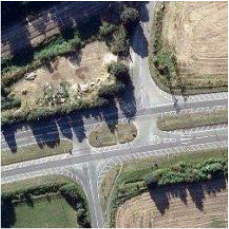
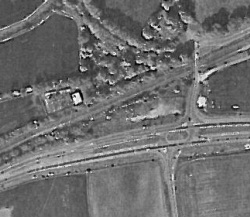
The site is approximately 0.3ha. The site location can be seen in BDS Architects Drawing SY
A90 “Location Plan” as found in Appendix A. An aerial photo of the site can be seen in BDS
Architects Drawing SYA92 “Aerial Plan” as found in Appendix A.
8.2 Current Site Description
The following description is based on information made available from internet mapping and
aerial photography.
The site is located in a rural area with much of the surroundings undeveloped. The site is
broadly rectangular in shape and is accessed from a road along the north boundary of the
site. Railway lines exist to the west of the site beyond which is an electrical substation south
east, a road to the north and the main A1301 road to the east. A drainage ditch with
accompanying ponded area is located south of the site boundary.
The site is undeveloped and comprises of vegetation in the form of grass, trees and shrubs.
Anecdotal evidence including aerial photography suggests that during development of
adjacent infrastructure e.g. A1301 road, the site was physically raised by up to 2 metres
through tipping of backfill on to the site.
8.3 Existing Flood Risk
Fluvial
There are no surface water features present on the site.
The closest water feature is indicated as a Tertiary River (Drainage Ditch) which is located
along the southern boundary of the site. It is not a designated EA main watercourse.
With reference to Ordnance Survey mapping the River Cam is located approximately 140m
from the site and flows in a southwest to north east direction.
The EA website Flood Risk Map can be seen in Figure 1. This indicates the site is in Flood
Zone 2 (medium probability of flooding) a different flood zone to that provided in the SCDC
Strategic Flood Risk Assessment (SFRA). There are no flood defences close to the site.
The SCDC SFRA incorporates more detailed flood modeling and the resultant mapping
indicates that the site is in Flood Zone 1 – low annual probability of flooding. This zone
comprises land assessed as having a less than 1 in 1000 annual probability of river or sea
flooding in any year (<0.1%).
An extract from the SFRA can be seen in Figure 2.
A summary of the key SFRA maps relevant to the site is provided in Table 1.
Table 1: Summary of Key SFRA Mapping
Land at Mill Lane & A1301 Junction,
Sawston
South Cambridgeshire
7 April 2012
Table of Contents
If this report has been released electronically, the appendices referred to herein can be found in the
annexed zip folder/s as .pdf or .dwg files. If this report has been released in hard copy the appendices
will be bound into the back of this report. Plans may be annexed separately as A1 or A0 copies where
a bound-in A3 copy is not appropriate.
1.0 Scope ........................................................................................................................................ 3
2.0 Executive Summary ................................................................................................................. 3
3.0 Introduction ............................................................................................................................... 4
4.0 Purpose of the Report ............................................................................................................. 4
5.0 Report Information Sources .................................................................................................... 4
7.0 Overview of British Legislation ............................................................................................... 5
7.1 National Planning Policy ..................................................................................................... 5
7.2 Local Policy ........................................................................................................................... 5
8.0 Site Status and Environmental Setting ................................................................................. 5
8.1 Site Location and Status ..................................................................................................... 5
8.2 Current Site Description ...................................................................................................... 6
8.3 Existing Flood Risk ............................................................................................................... 6
9.0 Assessment of Proposed Development .............................................................................. 10
9.1 Proposed Development ..................................................................................................... 10
9.2 Flood Risk Vulnerability ..................................................................................................... 11
9.3 Surface Water Runoff – Flood Risk from the Development ......................................... 11
9.4 Climate Change .................................................................................................................. 14
9.5 Flood Evacuation Plan ....................................................................................................... 14
10.0 Conclusion ............................................................................................................................... 14
10.1 Recommendations for Further Work ............................................................................... 15
11.0 Appendices .............................................................................................................................. 15
1.0 Scope
This report contains the details of a Flood Risk Assessment carried out by Arbtech
Consulting Limited (“Arbtech”) for the proposed development of Land at Mill Lane & A1301
Junction, Sawston, South Cambridgeshire.
This report has been prepared for Conrad Bay Ltd and must not be relied upon by any other
party without the explicit written permission of Arbtech Consulting Limited.
All parties to this report do not intend any of the terms of the Contracts (Right of Third
Parties Act 1999) to apply to this report.
Please note this report does not purport to provide definitive legal advice.
The Executive Summary contains an overview of key findings and conclusions. However, no
reliance should be placed on the Executive Summary until the whole of the report has been
read.
Other sections of the report may contain information which puts into context the findings
noted within the Executive Summary.
All rights reserved. No part of this report may be copied, edited, transmitted,
reproduced, hired, lent, sold or disclosed without the prior written consent of Arbtech
Consulting Ltd. Any action taken or omitted to be taken in reliance upon the content
of this report is not permitted and may be unlawful. Copyright © Arbtech Consulting
Ltd 2011.
2.0 Executive Summary
Arbtech conducted a Flood Risk Assessment for the site at Mill Lane & A1301 Junction,
Sawston, South Cambridgeshire. The site is approximately 0.3ha in size.
This FRA has been carried out in accordance with the 27th March 2012 National Planning
Policy Framework (NPPF) which replaced “PPS25: Development and Flood Risk”. It is to be
used to assist the Local Planning Authority (LPA) and Environment Agency (EA) when
considering the flooding issues of the proposed development as part of a planning
application.
The proposed development is to construct 3 commerical units, with associated car parking
and landscaping including SUDS in the form of ponds to ensure there is no change in the
hydraulic impact of the site.
According to the Environment Agency website map, the site is located within EA Flood Zone
2 (medium probability of flooding). The South Cambridgeshire Strategic Flood Risk
Assessment (SFRA) based on detailed modelling indicates the site is in Flood Zone 1 (low
probability of flooding). The site is therefore located in an area which is considered to have a
low risk of flooding.
The South Cambridgeshire SFRA indicates there was a flood recorded in the area which
included the site in 1968.
The site is protected from flooding by the embankment of the railway to the west and by the
A1301 to the east. The site itself has also been raised relative to the boundaries.
The drainage ditch to the south is culverted on either side of the site the site is protected
from surcharging due to the surrounding topography (A1301 and the railway). The proposed
buildings will not be located adjacent to the ditch.
Based on the SFRA mapping, there is safe access to the north of the site which is higher
ground and there is a large area within Flood Zone 1 as a safe refuge.15
The proposed development will incorporate an appropriate drainage strategy such that it is
considered there will be no unacceptable impacts on the adjacent infrastructure i.e. the
railway and A1301.
The most sustainable form of SUDS, in the form of attenuation pond(s) is to be incorporated
as part of the scheme. The pond(s) are to be sized using the 1 in 100 Year + Climate
Change storm event, to ensure there is no impact on the receiving ditch. The pond will also
act as a reed bed foul water treatment pond and will also operate as a benefit to biodiversity.
The project ecologist will have input to the design (shelf areas) and planting scheme.
Generally the site is considered to have a low flood risk based on the site topography and
physical constraints to flood flow paths reaching the site.
Based on the likely flooding risk it is considered that the proposed development can be
operated safely in flood risk terms and is therefore appropriate development in accordance
with PPS25.
It is recommended that the development signs up to the EA Flood Warning scheme and, if
appropriate, a Flood Evacuation Plan is provided for the future tenants.
3.0 Introduction
Arbtech was instructed by to carry out a Flood Risk Assessment (FRA). The study site is
Land at Mill Lane & A1301 Junction, Sawston, South Cambridgeshire.
The FRA combined a desktop study, review of available information, consultations and an
assessment of all sources of flooding posed to and from the site and proposed development,
in accordance with National Planning Policy Framework (NPPF). Appropriate flood mitigation
measures were then considered, either as already incorporated within the scheme or
recommended for inclusion at detailed design stage. The suitability of the proposed
development was also reviewed in the context of guidance provided by PPS25.
4.0 Purpose of the Report
This FRA has been carried out in accordance with National Planning Policy Framework
(NPPF). It is to be used to assist the Local Planning Authority (LPA) and Environment
Agency (EA) when considering the flooding issues of the proposed development as part of a
planning application.
The report provides the following information:
• An assessment of the flood risk posed to the site based on flood information and
mapping provide by the EA and Strategic Flood Risk Assessment (SFRA);
• An assessment of the proposed development in terms of surface water run-off; and
• Proposals for measures to mitigate the flood risks posed to and from the
development where appropriate in accordance with NPPF (March 2012).
5.0 Report Information Sources
The information source used to undertake this FRA has been collected from the following
sources:
• National Planning Policy Framework (NPPF) and NPPF Technical Guidance (March 2012
• Phase 1 Contaminated Land Risk Assessment report (Arbtech, 2012) including
Groundsure Enviro-Insight Mapping (March 2012)
• British Geological Survey Website (accessed March 2012)
• EA Website (accessed March 2012);
• South Cambridgeshire District Council Strategic Flood Risk Assessment (September
2010);
• Cambridge City Council “Sustainable Drainage: Cambridge Design and Adoption
Guide” (December 2009);
• Cambridge County Council Surface Water Management Plan (May 2011)
• South Cambridgeshire District Council Website (accessed January 2012);
• Cambridge Flood Risk Management Partnership (accessed March 2012);
• Internet mapping and searches.
7.0 Overview of British Legislation
7.1 National Planning Policy
The National Planning Policy Framework (NPPF) and accompanying Technical Guidance
was published on the 27th March 2012. This supercedes all Planning Policy Statements
(PPS’s) and remaining Planning Policy Guidance (PPG’s). Flood risk is retained as a key
development consideration and is incorporated within Section 10: “Meeting the challenge of
climate change, flooding and coastal change”:
“Inappropriate development in areas at risk of flooding should be avoided by directing
development away from areas at highest risk, but where development is necessary,
making it safe without increasing flood risk elsewhere.”
The Sequential and Exception Tests (as per PPS25) are retained as part of the NPPF. The
accompanying NPPF Technical Guidance also includes Tables 2 and 3 (similar to Tables D2
& D3 of PPS25) to assist with flood risk vulnerability classifications and development
suitability.
7.2 Local Policy
Cambridge County Council and South Cambridge District Council consider flood risk through
relevant environmental and climate change policies which enforce the requirements for the
former PPS25 (now superceded by the NPPF).
The Strategic Flood Risk Assessment (SFRA) for South Cambridgeshire District Council is
the key source of flood risk specific information for the area. The SFRA provides a more
detailed review of flood risks and recommendations for ensuring developments can be
constructed and operated safely in accordance with PPS25. Greater detail of the SFRA is
provided in the report.
8.0 Site Status and Environmental Setting
8.1 Site Location and Status
The centre of the site is given as approximate National Grid Reference 547561, 249467
The site address is Land at Mill Lane/A1301 Junction, Sawston-By Pass, Sawston,
Cambridgeshire (nearest postcode CB22 3BY). The village of Sawston is located on the
other side of the A1301 and c. 150m east of site.
The site is approximately 0.3ha. The site location can be seen in BDS Architects Drawing SY
A90 “Location Plan” as found in Appendix A. An aerial photo of the site can be seen in BDS
Architects Drawing SYA92 “Aerial Plan” as found in Appendix A.
8.2 Current Site Description
The following description is based on information made available from internet mapping and
aerial photography.
The site is located in a rural area with much of the surroundings undeveloped. The site is
broadly rectangular in shape and is accessed from a road along the north boundary of the
site. Railway lines exist to the west of the site beyond which is an electrical substation south
east, a road to the north and the main A1301 road to the east. A drainage ditch with
accompanying ponded area is located south of the site boundary.
The site is undeveloped and comprises of vegetation in the form of grass, trees and shrubs.
Anecdotal evidence including aerial photography suggests that during development of
adjacent infrastructure e.g. A1301 road, the site was physically raised by up to 2 metres
through tipping of backfill on to the site.
8.3 Existing Flood Risk
Fluvial
There are no surface water features present on the site.
The closest water feature is indicated as a Tertiary River (Drainage Ditch) which is located
along the southern boundary of the site. It is not a designated EA main watercourse.
With reference to Ordnance Survey mapping the River Cam is located approximately 140m
from the site and flows in a southwest to north east direction.
The EA website Flood Risk Map can be seen in Figure 1. This indicates the site is in Flood
Zone 2 (medium probability of flooding) a different flood zone to that provided in the SCDC
Strategic Flood Risk Assessment (SFRA). There are no flood defences close to the site.
The SCDC SFRA incorporates more detailed flood modeling and the resultant mapping
indicates that the site is in Flood Zone 1 – low annual probability of flooding. This zone
comprises land assessed as having a less than 1 in 1000 annual probability of river or sea
flooding in any year (<0.1%).
An extract from the SFRA can be seen in Figure 2.
A summary of the key SFRA maps relevant to the site is provided in Table 1.
Table 1: Summary of Key SFRA Mapping
SFRA DRAWING
K
Figure B3.6: Fluvial Flooding History Figure B3.7: Sewer Flooding History Figure B4.4: Surface Water Flooding |
Site Specific SFRA Designation / Description
There are no records of fluvial flooding for the site. There are records of fluvial flooding from the River Cam in the area of the site, including Mill Lane c. 50m to the west of the site. There are no records of sewer flooding for the site. There are no records of sewer flooding for the immediate area of Sawston. The site is not in an area of surface water flooding. The surrounding areas are affected by sewer flooding. The A1301 acts as a barrier from surface water to the east and the railway embankment provides a barrier from surface water to the west. |
 |
 LIGHT BLUE INDICATES AREA THAT FLOODS ONLY AT TIMES OF EXTREME THE MAP DOES NOT TAKE INTO ACCOUNT THE SITE HAS BEEN RAISED CONSIDERABLY OVER THE YEARS AS SHOWN BY TOPOPRAPHIC LAZER SURVEY CARRIED OUT CFOR CONRAD BAY LTD
|
 |
However, there are no records from the existing site users of the site being flooded as result
of groundwater.
The proposed development does not include any works which could increase the risk of
flooding to or from the development from groundwater sources.
Artificial Sources of Flooding
There are no known reservoirs, canals or major lakes in the immediate area. The site is
located greater than 4 kilometres (km) from the nearest reservoir indicated as Babraham
Reservoir in Figure B4 of the SCDC SFRA. There is a culverted drainage ditch located 10m
to the southeast (under the A1301) and southwest (under the railway) of the site.
Other Sources of Flooding (Infrastructure and Site Drainage)
It is assumed that the site is currently free draining and any pluvial water currently infiltrates
and or reaches the highway drainage to the north or the drainage ditch to the south of the
site.
The site is not in an area of surface water flooding. The surrounding areas are affected by
sewer flooding; however from available SFRA mapping it is indicated that the A1301 acts as
a barrier from surface water to the east and the railway embankment provides a barrier from surface water to the west.
The site and area is not subject to a detailed model as part of the Surface Water
Management Plan (SWMP) for Cambridge City and South Cambridge.
The SWMP does identify the area of Sawston to the east of the site as a “Wet Area”. There were 28 recorded flood incidents in the SWMP for Sawston but none of the roads identified were proximate to the site.
Stretch of Ditch Between the Two Culverts
The principle source of flooding is therefore likely to be surface water (pluvial) flooding from overland flow also associated with capacity of the ditch located south of the southern boundary. However, the receiving flows in the stretch of ditch directly adjacent to the site are dictated by culverts which are located to the west and east of the site. This would limit the amount of flow in the stretch between the two culverts directly south of the site. Surcharging between the two culverts could increase the risk of inundation of the southern area of the site.
The existing modeling suggests that the flows remain tight to the drainage ditch location rather than inundating the site, again, largely due to the raised nature of the site. The relationship between the site topography and the drainage ditch hydraulic dynamics should be investigated further at detailed design to minimise increased risk of inundation to the site and increased risk of flooding to surrounding areas. It should be noted that the substation is located on the other side of the railway to the west and therefore the proposed development is considered note likely to have an impact on the flood profile on the other side of two railway embankments and a section of culvert
Flood History
From available information the site was inundated by the 1947 flood event (See SFRA Map
B.3.4 included in Appendix A). The site is not indicated as being inundated in more recent
historic fluvial or other source of flood recordings.
Key Flooding Sources
A summary of the key flooding sources relative to the site that have been identified from
available sources is provided in Table 1:
9.0 Assessment of Proposed Development
9.1 Proposed Development
The proposed end use of the site is shown in BDS Architects Preliminary Drawing SYA91
“Site Plan” as found in Appendix A.
Proposals include 4 buildings with 1 split into 4 units and 1 split into 2 units, car and cycle
parking with an allowance for 35 and 20 spaces respectively along with recycling and bin
storage, gabion wall and landscaped bunding, a surface water and foul water attenuation
pond with structured planting around the perimeter of the site. The site access will remain
the same however the existing entrance will be set back and widened to 7.3m.
9.2 Flood Risk Vulnerability
The site is disused and the surroundings include important infrastructure including a national
railway to the west and a major road (A1301) to the east.
According to Table 2 of the NPPF Technical Guidance (Flood Risk Vulnerability
Classification in NPPF), the proposed commercial / industrial land use would be classified as
“Less Vulnerable.”
Table 3 (Flood Risk Vulnerability and Flood Zone “Compatibility”) in NPPF Technical
Guidance states that a “Less Vulnerable” development in Flood Zone 1 is appropriate in
flood risk terms.
The landuse would also be deemed to be appropriate in accordance with the NPPF (and
superseded PPS25) in Flood Zones 2 and 3a.
No NPPF Flood Exception Test is required.
9.3 Surface Water Runoff – Flood Risk from the Development
In accordance with NPPF and NPPF Technical Guidance, this FRA also considers the risks
posed from the development to surrounding areas.
It is assumed that the current site is free draining. There will be an increase in the amount of
impermeable areas on the site (buildings, roads and car parking areas).
The proposed development incorporates a suitable SUDS approach for the site and type of
development, following also the guidance “Cambridge Sustainable Drainage Design and
Approval Guidance” (2009).
Drainage Ditch
Surcharging between the two culverts could increase the risk of inundation of the southern
area of the site.
The existing modeling suggests that the flows remain tight to the drainage ditch location
rather than inundating the site, again, largely due to the raised nature of the site.
The relationship between the site topography and the drainage ditch hydraulic dynamics
should be investigated further at detailed design to minimise increased risk of inundation to
the site and increased risk of flooding to surrounding areas.
It should be noted that the substation is located on the other side of the railway to the west
and therefore the proposed development is considered note likely to have an impact on the
flood profile on the other side of two railway embankments and a section of culvert.
The proposed development will incorporate an appropriate drainage strategy such that it is
considered there will be no unacceptable impacts on the adjacent infrastructure i.e. the railway and A1301.
The proposed development will also incorporate new low-water demand devices such that
despite increasing the number of basins/toilets, the increase in peak flow and volume of flow
is likely to negligible.
9.4 Climate Change
The impact of climate change in accordance with NPPF is likely to be an increase in the
rainfall intensity in the future, which will increase peak storm flows to sewer. The proposed
development will incorporate a detailed drainage strategy which includes a 30% allowance
for climate change (i.e. in the detailed sizing of the attenuation structures) that adhers to the
SUDS hierarchy indicated in the sections above.
There will be no connection to sewers such that surrounding sewer capacities will not be
impacted.
The attenuation structure(s) are to be sized based on the 1 in 100 year storm event including
an allowance of 30% increase in rainfall intensity in order to accommodate for climate
change for the lifetime of the development.
Nevertheless, the proposed development will incorporate low flush and reduced water
demand showers and toilets, such that if the development does connect to surrounding
sewers, the combined flows to sewer, due to the size of the development, are likely to have
a negligible impact. It is considered therefore that flows in the future are not likely to have a
significant impact, even with an allowance for climate change.
There is unlikely to be an unacceptable impact on the receiving sewers owing to the small
scale of the development.
9.5 Flood Evacuation Plan
The Site is in Flood Zone 1 (low annual probability of flooding). It is however a site that is
“protected” to the west and east by infrastructure barriers that act to prevent the site being
inundated. The north access point has free access, directly adjacent to the north to a large
area in Flood Zone 1. Based on the likely flood risk, it is considered likely that there would be
sufficient time to evacuate to further large areas of Flood Zone 1.
It is recommended that the future tenants are provided with a Flood Evacuation Plan and
that the property signs up to the EA Flood Warning scheme, which would ensure in the event
of a flood, tenants are directed, when appropriate, to the areas north of the site.
10.0 Conclusion
The site is considered to be generally at low risk from all sources of flooding; the SCDC
SFRA indicates the site is in Flood Zone 1 (low probability of flooding). It is also likely that
based on the surrounding topography and structures, flood waters would flow away from the SITE
The proposed development is categorised as “Less Vulnerable” in accordance with NPPF
Technical Guidance; it is therefore an appropriate type of development within Flood Zone 1,
2 & 3a.
Based on the likely flooding risk, it is considered that the proposed development can be
operated safely in flood risk terms, subject to the recommendations below, and is therefore
appropriate development in accordance with the NPPF and accompanying Technical
Guidance.
10.1 Recommendations for Further Work
1. If site specific flood levels become available, the residual flood risk should be reevaluated;
2. A detailed topographic survey should be undertaken to understand the impacts of
any proposed changes in site levels and likely hydraulic connectivity / flow paths for
input to the drainage strategy and site layout;
3. The culverts and drainage ditch should be further investigated to establish capacity,
condition and maintenance responsibility and hydraulic dynamics west to east;
4. Detailed drainage designs to demonstrate surface and foul water volumes can be
attenuated on site;
5. Prepare a Flood Evacuation Plan for use by future tenants and sign up to EA Flood
Warning service.
11.0 Appendices
A. Site Location and SCDC SFRA Extracts
B. Proposed Plans and Elevations